 |
| Church |
Shillong(Khasi: Shillong) is the capital of Meghalaya, one of the smallest states in India and home to the Khasis. It is also the headquarters of the East Khasi Hills district and is situated at an average altitude of 4,908 feet (1,496 m) above sea level, with the highest point being Lum Shyllong at 6,447 feet (1,965 m). The city had a population of 260,520 according to the 2001 census. It is said that the rolling hills around the town reminded the European settlers of Scotland. Hence, Shillong is also known as Scotland of the East.
Shillong is a beautiful city and is surrounded by pine trees. Standing 1496m, it provides welcome relief from the heat. This capital of Meghalaya derives its name from the deity Shyllong or Lei Shyllong, who is worshipped at the Shillong Peak. It is dotted with neat Victorian Bungalows and little churches and has a golf course which is one of the best (and also one of the wettest) in the country. Shillong has always been the meeting point of traditional cultures and cosmopolitan styles. Termed as "Scotland of the East" it is the capital of Meghalaya. This hill resort is unique in its scenic beauty and culture. A fresh balmy air and a bracing climate makes Shillong a place for all seasons. The tribes of Khyrim, Mylliem, Maharam, Mallaisohmat, Bhowal and Langrim trace their descent from Shillong.
Geography of Shillong
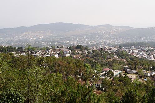
The capital of Meghalaya, Shillong lies on the eastern part of the state. Perched at an altitude of 1,520 meters (4,990 feet) above sea level, the city stretches for about 6 km on an elevated tract. It is situated on a plateau bound on the north by the Umiam gorge, on the northwest by the great mass of the Diengiei Hills that rise up to a height of 1,823 meters (6077 ft.) above sea level, and on the northeast by the hills of the Assam valley. The Umshyrpi and the Umkhra rivers, which finally merge and form the Umiam River, water it (Interactive map of Shillong). Shillong is at distance of 104 km from Guwahati, 295 km from Kaziranga, 578 km from Siliguri and 658 km from Darjeeling.
Shillong is located at 25°34′N 91°53′E / 25.57°N 91.88°E / 25.57; 91.88. It is on the Shillong Plateau, the only major pop-up structure in the northern Indian shield. The city lies in the centre of the plateau and is surrounded by hills, three of which are revered in Khasi tradition: Lum Sohpetbneng, Lum Diengiei and Lum Shillong. Shillong is said to be the second largest hill station in the world after Brasillia.
- Best time to travel : Autumn (September to November) and Winter (November to March)
- Weather Conditions : Pleasant, pollution-free; Summers: The temperature varies from 23 °C (73 °F); Winters: The temperature varies from 4 °C (39 °F).
- Location : Shillong, the capital city of Meghalaya is just 56 km (35 mi) from Cherrapunji, the world's wettest place.
History of Shillong
Shillong was a small village until 1864, when it became the new civil station of the Khasi and Jaintia hills. It remained the summer capital of Eastern Bengal and Assam for many years. In 1874, on the formation of Assam as a Chief Commissioner’s Province, it was chosen as the capital of the new administration. An earthquake destroyed the city in 1897, necessitating its complete rebuilding. In January 1972, Shillong became the capital of the newly formed state of Meghalaya.
 |
| Shillong Town(P.B) |
 |
| Way to Cherrapunji |
 |
| OLD BUS |
 |
| View from Shillong Peak |


Great Site,
ReplyDeleteYou Can Check Shillong Teer Result